
Don Sahong Dam Hydropower Info - by Hobo Maps - Go to Hydropower Web Page --- Home
Don Sahong Dam is a hydropower project on the Mekong River in Siphandone (4000 Islands) area of Champasak Province, Lao PDR, less than two kilometers upstream from the Lao-Cambodia border. It is a run-of-river type hydroelectric project at the downstream end of the Hou Sahong channel between Don Sahong and Don Sadam islands.
Don Sahong Dam barrage and switchyard image below:

Satellite image of Don Sahong Dam location below at coordinates - 13°56'38.4"N 105°57'21.6"E (13.944, 105.956)


The developer of the Don Sahong Dam is Mega First Corporation Berhad, a Malaysian company. The Don Sahong Power Company has an agreement with the government of Laos on a build, operate and transfer basis (BOT) with a concession period of 25 years. An engineering, procurement and construction contract with Sinohydro was signed on 15 October 2015 allowing the start of construction. The hydropower plant began commercial operations (COD) in January 2020.
The owner of the project is Don Sahong Power Company Ltd. with Mega First Corporation Berhad (80%) and EDL GEN as a 20% shareholder.
Don Sahong Dam site image below with resettlement housing at bottom:

The project takes advantage of a natural drop of about 20 meters in the Mekong River along the ‘Great Fault Line’. The gross head on the project varies between 13 to 21 meters depending on seasonal variation in flows. The Mekong River is braided in this area with seven main channels and many sub-channels.
The 100-meter wide dam structure and its U-shaped embankment extensions extend a total of 6,800 meters in length to create a raised pond.
Satellite image below shows braided channels of Mekong River around Don Sahong project.

The dam structure is 22.5 meters high and has capacity of 260 MW from four bulb turbines 65 MW each. An expansion program is under way in year 2023 to add a 5th 65 MW turbine which will bring total installed capacity to 325 MW. The developers claim the plant will then be able to generate about 2,000 GWh output per year. See more details below near the bottom of this web page.
Don Sahong Dam barrage images below:


The project has a 260 MW power station in a 100 meter-wide concrete barrage dam structure at the downstream end of the Hou Sahong channel. Embankments have been built up along the upriver islands of Don Sadam and Don Sahong that border the Hou Sahong. A small reservoir or headpond is contained within the sidewall embankments of these two islands.
The sidewall impounding embankments in total are about 6,800 meters long with height decreasing from 25 meters at the downstream end down to near zero at the upstream end.


The project causes water to back up in Hou Sahong channel creating a headpond with a surface level that will vary somewhat with the level of the Mekong upstream. The top of the dam is set at 76.9 meters above sea level which is above the maximum level that the Mekong historically achieves at the upstream entrance to the Hou Sahong channel. The surface level of the reservoir is expected to vary about 3.2 meters during the year (along with the Mekong) with its highest level in August-September and lowest level in April-May each year.
The Hou Sahong Channel flow on average takes only about 15% of the total Mekong flow.
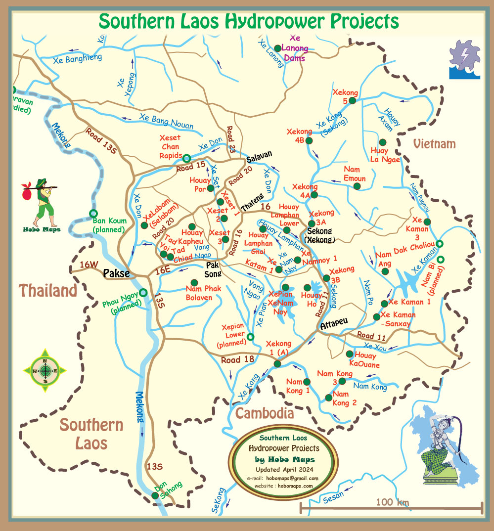
Don Sahong Dam Hydropower Project location below:

The Project Features
Nice project videos can be seen at Mega First website
Don Sahong embankment structure image below:

Don Sahong head pond channel dredging and embankment shown below:

Mekong River style at Siphandone image below:


Don Sahong hydropower project view from Cambodia below:

Don Sahong Powerhouse interior images below:


Don Sahong switchyard below:

Overhead satellite image below of Don Sahong Dam Site


The electricity output from Don Sahong HPP was originally planned to be sold to EDL for domestic consumption but in 2020 an agreement was reached to sell all of the output to Cambodia. A 28 km dedicated 230 kv power transmission line connecting the power station with Cambodia was commissioned in early 2020. The export route to Stung Treng, Cambodia can be seen at the bottom of the map image below.

MRC Joint Environmental Monitoring (JEM) program results
Mekong River Commission (MRC) released a report August 2022 for the first cycle results of the Joint Environmental Monitoring (JEM) program that measures five key indicators of the Mekong’s health: hydrology, sediment, water quality, aquatic ecology and fisheries.
By testing at the two Mekong river hydropower projects in Laos– the Don Sahong HPP and Xayaburi HPP – the MRC aims to create monitoring methods and standards that all hydropower operators on the Mekong mainstream will follow in the future. A diverse team of monitors tested for roughly one annual cycle from 2020 to 2022 in spite of COVID causing significant delays.
Results show the Don Sahong and Xayaburi hydropower projects had moderate impact on water flow, sediment and fisheries while the overall river flow patterns did not change.
The Mekong river’s ecological health was “good” at upstream dam sites, “moderate” within the dam impoundment sites, and “moderate” downstream of both dams.
Water quality remains “within human health thresholds.” Within dam impoundments, there is no evidence of stratification – which can affect both water quality and fisheries. Once water passes through the dams, “there is little evidence of change in downstream water quality.”
The report recommends that Mekong mainstream hydropower projects should:
1. jointly introduce “targets or limits on the rate of water level change” in the Mekong mainstream;
2. implement a central communication notification system;
3. jointly operate low level gates for sediment transport; and
4. in the Don Sahong’s case, deepen the entrance of fish passages and improve their channels.
Their report will likely become a foundation for both future policies and monitoring activities. As the report itself states, their findings can shape future hydropower projects “siting and design.
See MRC website report HERE
Don Sahong HPP monitoring sites shown in map below:

Don Sahong project location at bottom of map below:
In year 2022 an expansion of capacity was started by constructing a new 65 MW powerhouse annex facility next to the existing powerhouse as seen in image below. The new combined capacity output will be 5 x 65 MW = 325 MW.

The Don Sahong HPP 65 MW Expansion Project is located on the right bank of the project with the expansion powerhouse about 70 meters away from the first-phase existing powerhouse.
The project consists of a left-bank non-overflow embankment, a right-bank non-overflow embankment, headrace, a powerhouse annex, an auxiliary powerhouse annex, an erection bay and a switchyard annex. The embankment is a concrete gravity dam with the crest elevation at 76.9 meters above sea level and height of 25.95 meters.
The dam crest on the right bank is about 94 meters long while the dam crest on the left bank is about 65 meters long.
The non-overflow embankments on the left and right banks enclose an upstream approach channel of the Expansion Project.
The powerhouse annex consists of the intake, the upstream bulkhead gate, the main powerhouse, the downstream auxiliary powerhouse, the tailrace emergency gate and tailrace.
The installed capacity of the expansion powerhouse is 65 MW, the design discharge is 400 cubic meters per second, the rated head is 17.8 meters and the unit installation elevation is 43.1 meters above sea level.
The original switchyard has been provided with one more transmission system unit and the double-circuit transmission line of the first-phase project is shared.
The additional unit will also enable Don Sahong HPP to carry out major maintenance works on its turbine-generator units during the dry season.
Temporary Don Sahong expansion cofferdam to be constructed along red line axis in image below.
