
Nam Ngum 5 Dam Hydropower Info by Hobo Maps - Go to Hydropower Projects Page - - Home
Nam Ngum 5 Hydropower dam and reservoir are located on the Nam Ting (river) in northern Lao PDR. The dam is located in Vientiane province and the powerhouse is in Xieng Khouang province. Nam Ngum is pronounced like "Nam Nyum".
Nam Ngum 5 powerhouse is located about 11 km east of Nam Ngum 5 dam structure and reservoir. The dam and reservoir are actually on the Nam Ting river that flows north. Most of the Nam Ting water is now diverted from the reservoir eastward to the powerhouse and only a small flow is allowed to continue through the dam structure into the Nam Ting riverbed which flows northward to eventually join with the Nam Ngum river.
Is confusing for the project reservoir to be called the Nam Ngum 5 Reservoir when it is actually on the Nam Ting river and not even close to the Nam Ngum river. Better to say it is the reservoir on the Nam Ting that feeds water to the Nam Ngum 5 powerhouse 11.3 km away near the Nam Ngum river.
Nam Ngum 5 Powerhouse is located about 11.3 km east of Nam Ngum 5 dam and reservoir as shown in image below - Coordinates of the powerhouse are 19°21'35.8"N 102°42'44.0"E (19.359955, 102.712223).
Nam Ngum 5 Dam images below:


Nam Ngum 5 Power Project began operations in December 2012. The Project is a joint investment between Power China Resources (85%) and EDL GEN (15%).
The 120 MW project has generating capacity of 507 GWh per year.
Sinhydro Corporation from China is managing the project. The power station began construction on October 1, 2008 and was officially put into commercial operation on December 2, 2012.
Financing for the $200 million USD project was expected to come primarily from the National Bank of China or another Chinese government financial institution.
All the power generated from the Project is to be supplied to EDL for domestic consumption in accordance with a Take-or-Pay Commitment for a period of 25 years. After the end of the concession period ownership of the plant will be transferred to the Lao government.
The 104-meter-high dam creates a reservoir that covers 483 sq km. The reservoir is planned to be flushed each year.
Full supply level of the reservoir is to be at 1,100 meters above sea level.
The project includes water-intake structures, a diversion tunnel 8.6 km long , a penstock 1.2 km long , a surge shaft 197 meters high, a tailrace tunnel 428 meters long and a booster station.
Nam Ngum 5 location in satellite image below:

Nam Ngum 5 location shown at low left part of topographic map below:

Nam Ngum 5 reservoir satellite image below is from MapCarta. Google Maps satellite imagery as of 2024 is very old and doesn't show the dam or reservoir so the coordinates may look wrong on Google Maps. Coordinates of the dam structure are 19°21'24.9"N 102°37'18.2"E (19.356911, 102.621721).

Nam Ngum 5 dam & reservoir site images below:


Nam Ngum 5 dam images below:


Nam Ngum 5 area image below:

Nam Ngum 5 powerhouse site image below:

Nam Ngum 5 powerhouse area image below

Technical information of the Nam Ngum 5 Power Project shown below:

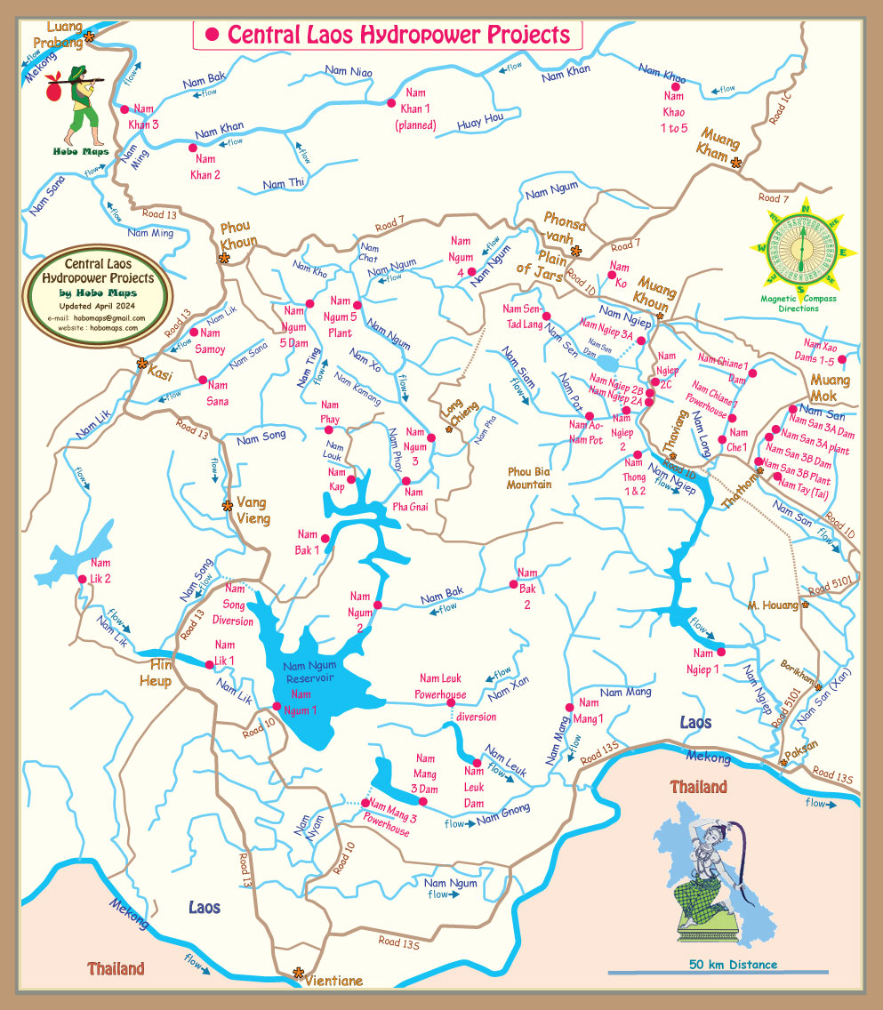
Nam Ngum 5 is located upstream of the Nam Ngum 3 Dam - in upper left part of map below:
Nam Ngum 5 project location below in Nam Ngum Basin image:


Nam Ngum 5 reservoir elevation of 1,100 meters above sea level as shown in chart below.

The developers report there was no resettlement resulting from the project and only 43 households of Ban Chim village were affected due to land occupation which includes paddy land, upland land and garden.
Nam Ngum 5 Hydropower Project was designed to qualify as a greenhouse-gas-reducing project under the Clean Development Mechanism (CDM) of the Kyoto Protocol and receive carbon reduction credits that can be sold. The goal is to encourage and subsidize clean and green power production that will eliminate the need to build more dirty polluting power plants. The CDM application form can be viewed or downloaded HERE .
Content below from Nam Ngum 5 EIA PDF report


![]()
