Glacial Origin of Jars at Plain of Jars, Laos - PDJ Jars Origin Theory - HoboMaps.com - Go to Plain of Jars Info Page - - - Home
Many people assume that all of the jars at the the Plain of Jars (PDJ) in Laos have been carved from quarried stone and that transport was neeeded to get the jars from the quarry to where we see them today. This may be true for the majority of jars but some jars may have been carved from naturally-situated boulders where early people found them lying on the surface where no transport was needed.
Boulders may have been brought down from the surrounding mountains in a prior Ice Age embedded in slowly-moving rivers of ice and deposited to where they are now in mounds when the ice melted. Some of these boulders may have been partially buried in the finer glacial debris but ended up lying on the surface as the finer material washed away over time from rains.
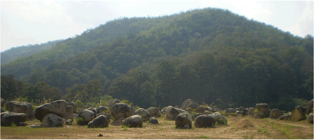
Mae Chan Thailand Boulders below on top of ridge in 2012 - this is the type of scene that may have been at PDJ that inspired the jar carving custom.
Humans may have come by and wondered at this strange scene of big boulders scattered about on hilltops with no clear source of where they came from or how they got there. If there was a lake covering much of the PDJ back then, some of these hilltops may have been islands in the the lake and the flat lowlands we see today would have been the bottom of that lake. This amazing scene of big boulders lying on islands in a lake may have seemed mystical and inspired the custom of carving them into hollowed-out funeral jars.
Likely examples of jars carved from glacially-deposited boulders are the jars found at the upper level of Jar Site 1, Site 2, the outer-lying satellite areas of Site 3 and the scattered jars found along the walk path between Sites 2 & 3.
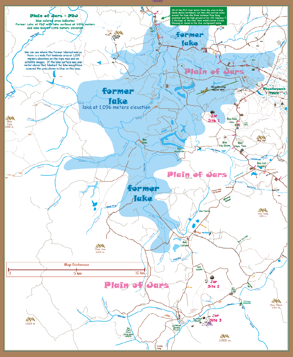
The map below is a hypothetical illustration of what areas a former lake may have covered at the PDJ. The depiction is based on elevation readings derived from Google Earth in 2014.
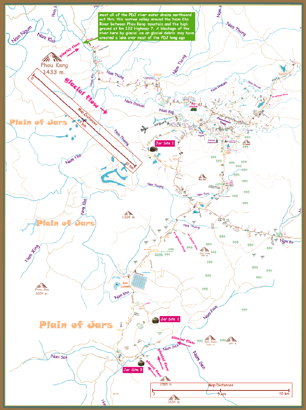
Sources of Ice Flows
It does seem that the PDJ is too far south to have been covered by large glacial ice sheets but it may have had smaller isolated ice flows such as those coming down from higher mountains on north-facing and tree-covered slopes. When visiting the areas around Jar Sites 1, 2 & 3 you can see in the surrounding hills for each site nearby higher mountains that could be the source of a former river of ice that could flow unimpeded to the jar site area. The higher areas of these source mountains are on average about 10 to 20 km distant from the sites and the elevation drop between their peaks and the jar sites ranges from 300 to 500 meters.
We can imagine a natural stream freezing over in a cold ice-age era and growing in size until this river of ice begins to move down plucking rounded boulders from the streambed and carrying them down to the plain and dumping them in a moraine mound at the end of the ice flow. A river of ice only a few meters thick and not very wide would be sufficient to carry the boulders.
There are official Thai government tourism reports of prehistoric glacial activity at Phu Prabhat Park in Thailand which has left boulder fields. This area is south of PDJ and the boulder fields seem similar to those seen at Jar Site 2 and Site 16 near Mouang Khoun.
The ridge just south of Jar Site 2 Ridge looks similar to a typical terminal moraine as depicted below:
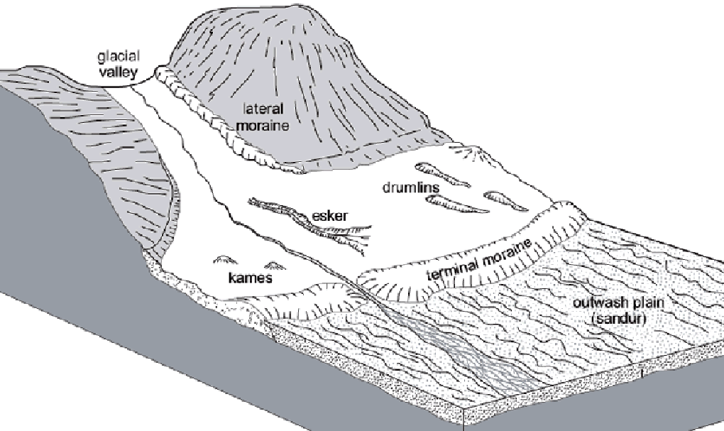
Moraine Mounds
Most of the hills or mounds that dot the PDJ seem scattered about in no pattern or logical scheme. There aren't ridges and gullies coming down from their peaks as most hills have after years of erosion. These PDJ mounds are mostly softly-rounded masses with some having faint concentric lines encircling them like the remnants of former terracing for crops.
If glacially-deposited boulders are on or inside these mounds then the composition of the mounds should be glacial till, loose and inconsistent rounded rocks and finer clay materials. If these mounds have solid seams of rock or bedrock inside them or significant organic materials, it would refute a glacian moraine theory.
Examples of terminal moraine mounds may be those arrayed in an arc ridge on both sides of Jar Site 2. The UXO-cleared path from Jar Site 2 to just north of Jar site 3 follows along this ridge going west. This arc shape may indicate the end of the ice flows as they changed courses annually, advancing and retreating seasonally and from year to year. It seems possible that all of the jars seen at the satellite (outer area) sites A, B, C & D at Jar Site 3 are on moraine mounds.
The illustration below shows possible sources and routes of rivers of ice that may have carried boulders to places where we find carved megalithic jars today.
3 likely sources of stone material used for the carving of jars
1. Stone boulders already at the jar site laying on the surface
2. Stone boulders laying on the surface at a remote location (a boulder field) such as at Phou Keng "Quarry"
3. Blocks of stone cut away from a larger mass of rock
The effort and tools needed for carving jars out of stone varies greatly between these 3 sources and it seems logical the carvers would have preferred using boulders already at a jar site since no transport is needed. When these were used up they would probably look for boulders at other places that could be carved and moved to the jar site. As a last resort they would make the big effort to cut blocks of stone away from a big mass, carve them into jars and transport them to the jar site.
When you visit Phou Keng "Quarry" you can see stone boulders lying on the surface that were partially carved into jars and never completed. It often looks like there was some fault line in the boulder that caused breakage during the carving or that the carver discovered the boulder was unsuitable to become a finished jar only after some wasted effort. The so-called "Quarry" is just a ravine that had natural boulders lying about suitable for carving into jars. No large mass of rock is seen there where blocks of stone were cut out for removal.
The carving of jars from boulders lying where humans found them provides an explanation of why some "missing" quarries may never be found.