
Sayaboury Dam / Xayaburi Dam / Hydropower Info by Hobo Maps - Go to Hydropower Projects Page - - - Home
Xayaburi (Sayaboury) hydropower project is located on the mainstream Mekong in Sayaboury (Xayaburi / Xaignabouli) province of Lao PDR about 30 km east of Sayaboury town.
The project is owned and developed by Xayabouri Power Co. Ltd.. Initial shareholders included CKPower, Natee Synergy, EDL Gen 20% and others.
Sayaboury Dam Hydropower Project images below:
Xayaburi hydropower project construction began on 15 March 2012 with Ch. Karnchang Public Company as the leading contractor. The project operates under a concession of 31 years from the commencement of commercial operations on October 29, 2019, after which the project becomes the property of the government of Lao PDR.
Financing loans of US $2.67 billion was provided by six Thai-based banks - Exim Bank, SCB, KTB, BBL, Bay & Tbank.

The engineering firm for the project was the Finnish company Poyry.
Andritz Hydro provided electro-mechanical equipment for the project including seven Kaplan turbines (each with an output of 175 MW), an additional 68.8 MW turbine, generators, governors, automation systems and additional equipment.
The Xayaburi hydropower project has a reinforced concrete dam 810 meters long with 28.5 meters net water head.
Seven turbine-generator sets of 175 MW each and one of 60 MW (maybe 68.8) generate electricity for sale to Thailand and Lao PDR. Total electric power generation capacity is 1,285 MW with average annual 7,370 GWh capacity able to be produced. The project is designed to continuously generate electricity and is not designed for peaking or part-time generation.
A power purchase agreement allows 1,220 MW electric output to be sold and delivered to Electricity Generating Authority of Thailand (EGAT) for a period of 29 years at a constant price.
Xayaburi hydropower project is located on the mainstream Mekong River about 30 km east of Xayaboury (Sayaboury) town as shown in satellite images below at coordinates 19°14'37.0"N 101°49'10.0"E (19.243611, 101.819444):


The Sayaboury dam on the Mekong river raises the water level on the upstream side close to the annual maximum water level of the Mekong in the flood season, creating a head pond that keeps the water within the historic river banks. The upstream head pond surface level is planned to not vary more than plus or minus one-half meter during the year.
The filling of the head pond is done once in the beginning of the project and the pond surface level is planned to be kept relatively constant after that. This head pond extends upriver all the way to Luang Prabang town where there is now a minimum Mekong river level maintained all year and many sandbars no longer appear in the dry season.
Downstream water levels below the dam will still be almost normal and fluctuate according to the season. Water inflow and outflow will be matched without additional retention in the head pond during the wet season.
Sediment Flushing operations are to be performed in the high flow season when relative changes in the flow are minimal.
The Sayaboury dam project layout is shown in image below:

The dam structure has a navigation boat lock 12 meters wide and 120 meters long to accommodate transit for ships of 500 tons and a fish ladder 10 meters wide for fish migration. It also has an emergency spillway to drain excess water flows in the wet season.
Navigation Lock attributes:
• Passage for vessels up to 500 tons capacity
• The backwater effect of the possible Pak Lay HPP has been considered;
• The upstream and downstream approaches are wide enough to allow large barges going in either direction;
• The design makes provision for a possible second parallel navigation lock along
the right abutment in the future; and
• The navigation lock has been modified to support fish passage.


Sayaboury Dam head pond diagram below shows the Mekong River surface water level raised all the way to Luang Prabang town and the planned downstream Pak Lay Dam would raise the Mekong surface level all the way up to Sayaboury Dam.

Sayaboury Dam power plant interior pictures below show huge sizes of rotors and turbine blades:


Turbine blades with large gaps allow fish blade strikes to usually not be fatal


Sayaboury Dam power transmission image below:
![]()
Sayaboury Dam navigation lock images below:

Sayaboury Dam site image below:

Sayaboury dam view below with fish ladder on right side.
Floating Trash and Debris Boom image below:

Sayaboury Dam fish passage image below shows routes for migratory fish to pass upstream (U/S) and downstream (D/S) through the dam structure.

Sayaboury Dam fish passage ladder image below under construction.

Sayaboury Dam fish lock control display below:

Sayaboury Dam concept image below shows specially-designed Kaplan turbines that allow some fish (not all) to pass safely downstream stream through the turbine blades and the dam structure.

Sayaboury Dam sand-flushing gates concept image below - used for flushing out excess sand sediment from head pond in wet season.

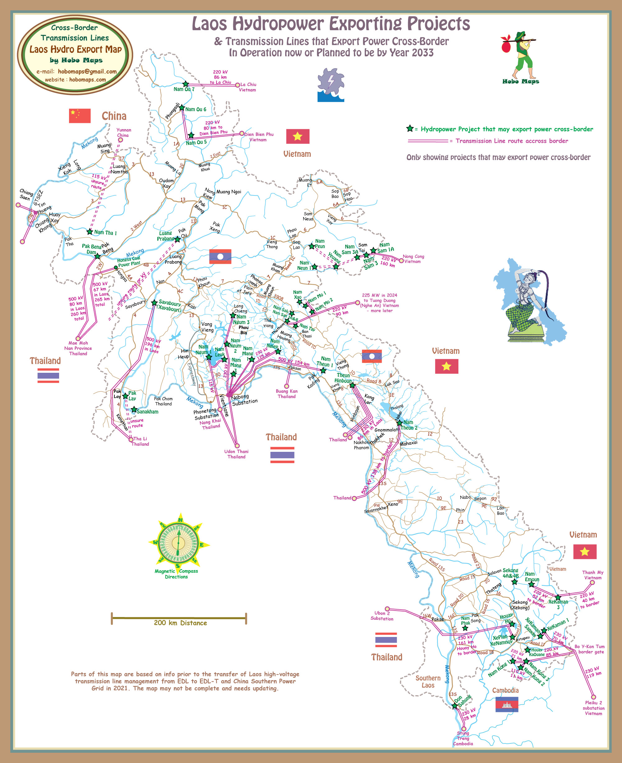
1,220 MW output from Xayaboury Dam is under Power Purchase Agreement for export to EGAT in Thailand by 500 kV transmission line route shown in map below (196 km long to Thai border). See enlarged version HERE.

The Mekong River Commission was active in suggesting changes be made to the original design of the hydropower facilities. The project design was changed to meet many suggestions and the changes are discussed below:
The changes include adjustments to the navigation lock which allows tractors and trailers to transfer small boats from upstream and downstream directions.
It will now take small boats only 15 minutes to get past the dam using land transport while previously it would have taken about 45 minutes.
The original fish passage had a steep slope so the new design has reduced this and made the passage way suitable for all sizes of fish.
The number of turbines at the fish passage section has been reduced from six to five to increase the percentage of fish that survive when passing through this section. An auxiliary feeding system will attract flow to the lower lock when the miter gate is closed.
In order to maximise the efficiency of the system, several independent fish passing facilities are included in the design:
– facility for upstream migration,
– fish passage recording system for upstream migration
– facility for downstream migration
– the navigation lock is adapted to serve as a fish lock
– space for a fish lift is included
Additional baseline data on fish is being collected and will be used to fine tune the
design of the fish passing systems.
Upstream The fishpass has been significantly modified and combined in a system with two fish locks, transferring the fish from the upstream end of the fishpass to a channel connected to the reservoir. An auxiliary powerhouse (8 MW) has been implemented to reduce power losses caused by the flow allocated to the fishpass. The fishpass has been made wider (18 m instead of 10 m), with four slots of different sizes instead of one, its slope reduced to 1.2 % and its flow significantly increased.
Provisions for the installation of a fish lift have been made, should it be necessary in the future to enhance the efficacy of the system and pass a greater biomass. A second fish pass facility on the right bank incorporated in the navigation lock is also provided. These facilities provide entrances for upstream migrating fish on either side of the powerhouse and at the downstream end of the navigation lock.
Downstream The downstream terminal chute will operate the whole year instead of only during the wet season. • A new pumping station was implemented to reduce the flow and power losses caused by the operation of this facility. • Minimum gap, Kaplan turbines are proposed.
--------------------
MRC Joint Environmental Monitoring (JEM) program results
Mekong River Commission (MRC) released report August 2022 for first cycle results of the Joint Environmental Monitoring (JEM) program that measures five key indicators of the Mekong’s health: hydrology, sediment, water quality, aquatic ecology and fisheries.
By testing at the two Mekong river hydropower projects in Laos– the Don Sahong HPP and Xayaburi HPP – the MRC aims to create monitoring methods and standards that all hydropower operators on the Mekong mainstream will follow in the future. A diverse team of monitors tested for roughly one annual cycle from 2020 to 2022 in spite of COVID causing significant delays.
Results show the Don Sahong and Xayaburi hydropower projects had moderate impact on water flow, sediment and fisheries while the overall river flow patterns did not change.
The Mekong river’s ecological health was “good” at upstream dam sites, “moderate” within the dam impoundment sites, and “moderate” downstream of both dams.
Water quality remains “within human health thresholds.” Within dam impoundments, there is no evidence of stratification – which can affect both water quality and fisheries. Once water passes through the dams, “there is little evidence of change in downstream water quality.”
The report recommends that Mekong mainstream hydropower projects should:
1. jointly introduce “targets or limits on the rate of water level change” in the Mekong mainstream;
2. implement a central communication notification system;
3. jointly operate low level gates for sediment transport; and
4. in the Don Sahong’s case, deepen the entrance of fish passages and improve their channels.
Their report will likely become a foundation for both future policies and monitoring activities. As the report itself states, their findings can shape future hydropower projects “siting and design.
See MRC website report HERE