Travel and Transport Info for Luang Namtha, Laos by Hobo Maps - - - Home
Click to see our Luang Namtha Town Map and our Luang Namtha Area Map
Railway - The new Lao-China Railway line that opened near the end of 2021 has a station in Ban Natuey (Boten Junction), Luang Namtha Province but there is no station in or near Luang Namtha town. Ban Natuey is about 30 km from Luang Namtha town on Highway 3 and getting between these towns by public transport is very limited. See the railway schedules HERE .
We can now confirm there usually are minivans waiting at the train station in Ban Natuey when trains arrive to carry passengers to Luang Namtha town for a fee of 60,000 kip per person.
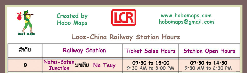
Railway Station hours below for Ban Nateuy town station:
Railway schedule & fares below at Nateuy
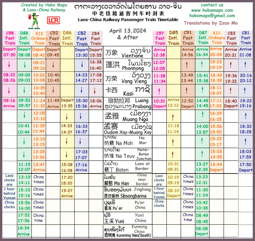

In March 2023 we didn't see any agents selling railway tickets in Luang Namtha for departure from Nateuy railway station.
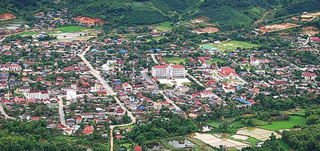
Luang Namtha
-Luang Namtha has clean paved streets and an unhurried and relaxed atmosphere. Many nice biking and hiking routes are outside of town where you still see traditional dress. Lush rice fields fill the wide valley and almost all harvesting is still done by hand. Modern electric bikes silently zip around town while strange weird agricultural vehicles operate outside of town. Plenty of fresh air in the wet season.
Getting Around
- Although Luang Namtha is on the Nam Tha River which connects to the Mekong, river travel is very limited. Most visitors arrive by road transport on Highway 3 from Huay Xay to the south or from China or Oudom Xay to the north and east. The highways around L. Namtha are in much better condition that most of the major roads in Laos.
There are two bus stations, a small bus station in central town at grid code GG208 on this map HERE and the main big bus station located about 10 km south of town at grid code KA197 on this map HERE. Recent departure schedules are below. Local transport around town is mostly by pickup truck songtaew buses that can be chartered as they don't have regular routes.
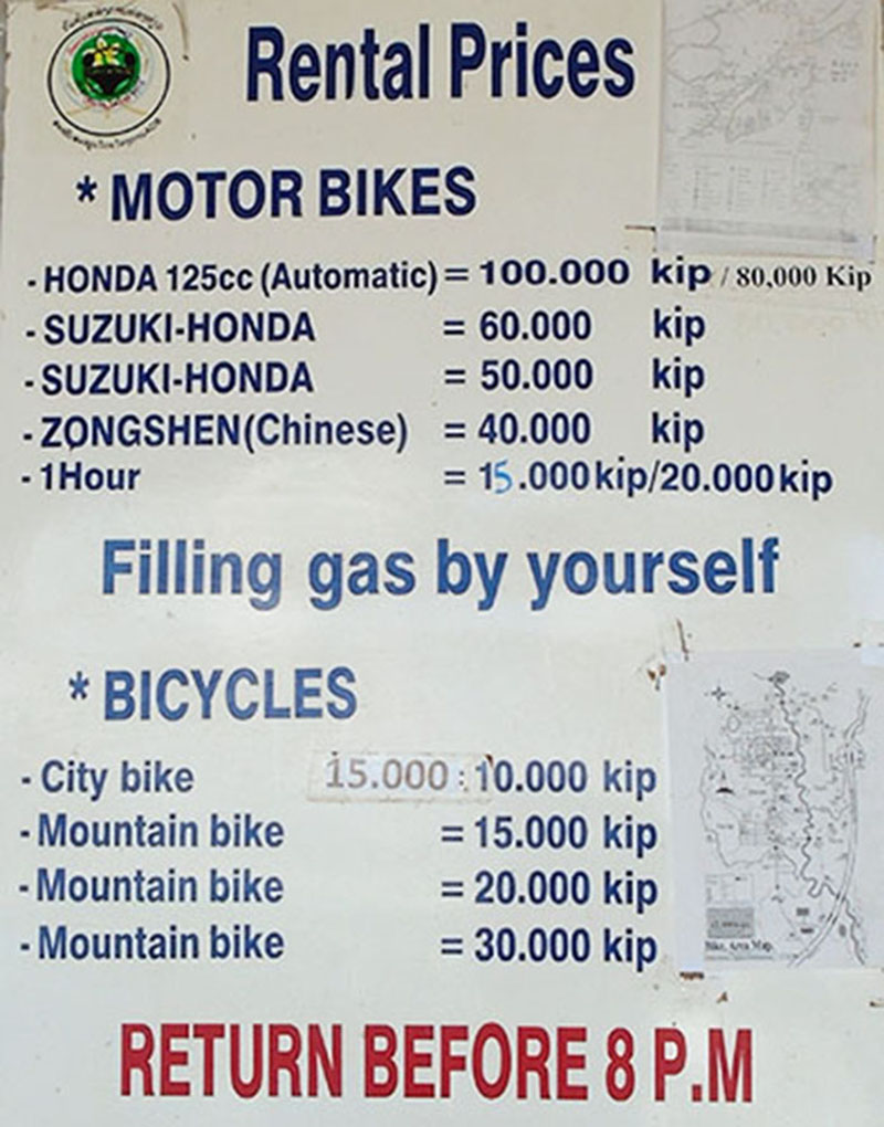
Nice quality bicycles were for rent at 15,000 kip per day in 2020 and motorbike rentals are also available. The town is small enough for walking to any place.
Nam Tha River Boat Trips
-In the past it was possible to take a 2 day boat trip on the Nam Tha river down to the Mekong at Pak Tha but there was no regular service and it required an overnight stay in the traditional boatmen's village of Ban Khone Kham, Nalae District. You can inquire at the Boat Landing Guest House at grid code JA200 on this map HERE to make arrangements but it usually requires you to form your own group and charter the entire boat.
We were quoted a price of 8,000 baht for the boat charter a few years ago. These trips may not be possible when the river is low in the dry season January to March. The new Nam Tha 1 hydropower dam is now finished and may block river travel for large boats as we don't see a transit lock in the dam's design HERE.
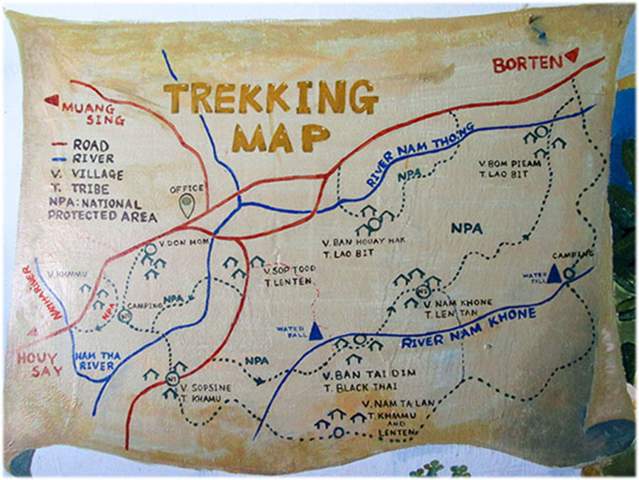
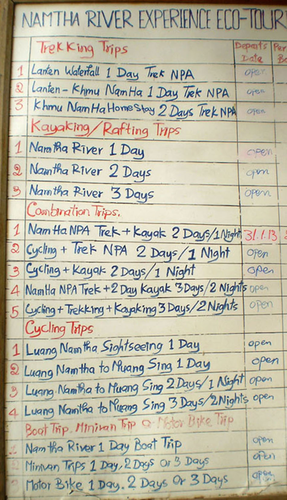
Trekking and Exploring
- The center of Luang Namtha Province has been designated as the Nam Ha National Protected Area and strectches from the Chinese border through the middle of the province, covering over 222,400 hectares. Luang Namtha is known as the birthpace of ecotourism in Laos and has many options for exploration, some of which are only available on a seasonal basis.
Tourism Office in Luang Namtha is at grid code GA207 on THIS MAP . Open Monday to Friday 08:00 - 11:30 & 13:30 - 16:00.
BUS SCHEDULES
March 2024 Bus Schedule below is from Luang Namtha outer bus station located about 10 km south of central Luang Namtha town at grid code KA197 on this map HERE.
08:30 bus to Phongsaly (200 km) goes thru China and is only for Lao & Chinese nationals.
Note 09:30 bus to Nong Khiaw at very bottom. The 2:30 bus to Luang Prabang is actually 14:30 departure or 2:30 PM.
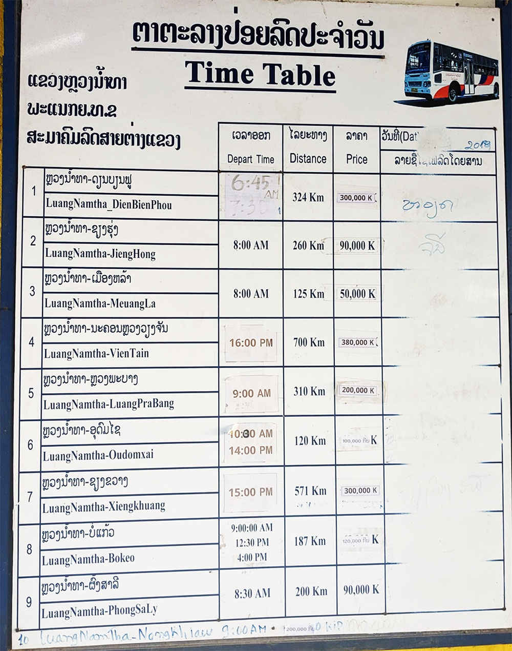
Some buses that go thru the outer bus station aren't on the schedule above because they start in different places - such as the Bokeo to Oudom Xay bus that stops for a lunch break around 13:00. These buses are usually happy to take on more passengers so just look for them parked by the restaurants and talk to the driver directly.
In Feb. 2024 our Oudom Xay to Bokeo bus stopped on the highway outside of the L. Namtha bus station around 13:00 to drop off and pick up passengers so best to wait by the highway instead of inside the bus station for this bus.
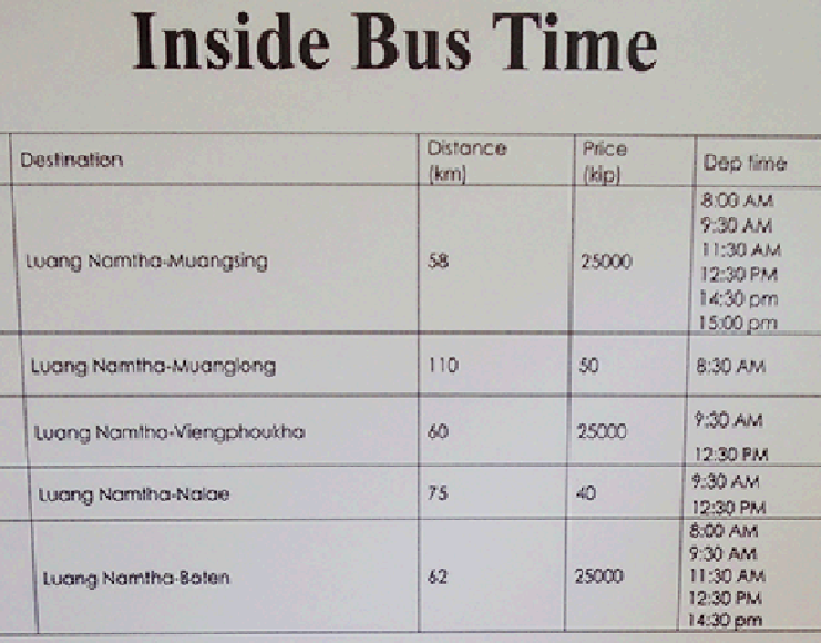
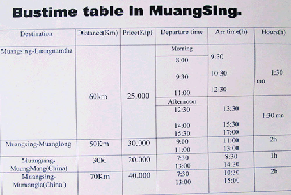
CENTRAL BUS STATION SCHEDULE BELOW for inner station in central town at grid code GG208 on this map HERE- pictures taken June 2018.
- has buses to Muang Sing, Muang Long, Vieng Phouka, Nale & Boten
the international buses to China below are now suspended due to the pandemic in 2020 & 2021 & 2022
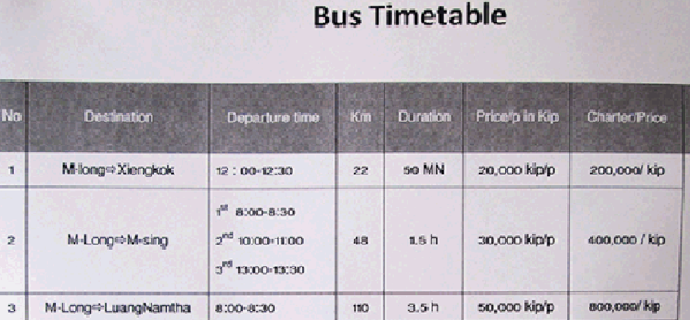
below schedule June 2019 - Buses from Muang Long to L. Namtha, Muang Sing & Xieng Kok
Luang Namtha Airline Connections are available between Luang Namtha and Vientiane
Trekking signs from October 2015 below:

Misc. Info. below
If you go out to see the Nam Dee waterfall in Dec. to March be on the lookout for Lanten ladies making large sheets of paper in the stream about 1 km before the waterfall at grid code FK242 on this map HERE. Buying a sheet or two from the maker will help keep this fascinating tradition alive.
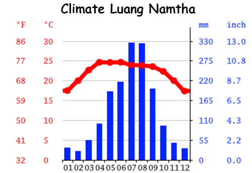
Best weather in Luang Namtha is November to February. The southwest monsoon arrives in Laos between May and July and lasts into October.
Ethnic Diversity around Luang Namtha