Travel and Transport Info for Muang Sing, Laos by Hobo Maps - - - Home
Muang Sing town below:
Click to see our Muang Sing Town map and our Muang Sing Area map
Travel to Muang Sing
- Muang Sing is located in a rather remote corner of NorthWest Laos and beyond the range of the big buses. Most visitors arrive by minivan or songtaew bus from Luang Namtha via Highway 17, a nice paved road. There is also a nice paved road connecting to the Chinese border but this border crossing isn't open for nonresidents. A decent road also connects to the Mekong at Xieng Kok, far to the southwest but some of it is not paved and quite dusty in the dry season.
Muang Sing has become oriented towards Chinese visitors the last few years and finding non-Chinese accommodation and food is becoming difficult.
Bus Service
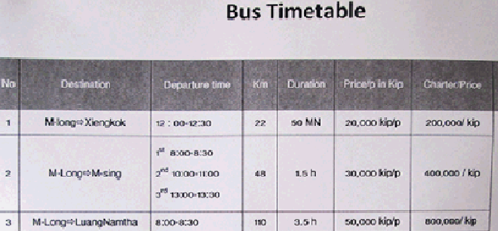
- The bus station in Muang Sing is located near the traditional market in town at grid code FF174 on this map HERE. Small and mid-sized buses go to Luang Namtha daily in the mornings and mid-day every couple hours or so depending on how busy things are. Similar buses head to Muang Long and Xieng Kok on a less regular basis. The bus schedule below was posted at the Luang Namhta Tourism Office June 2015. There were no schedules posted at the Muang Sing bus station on our last visit April 2015.
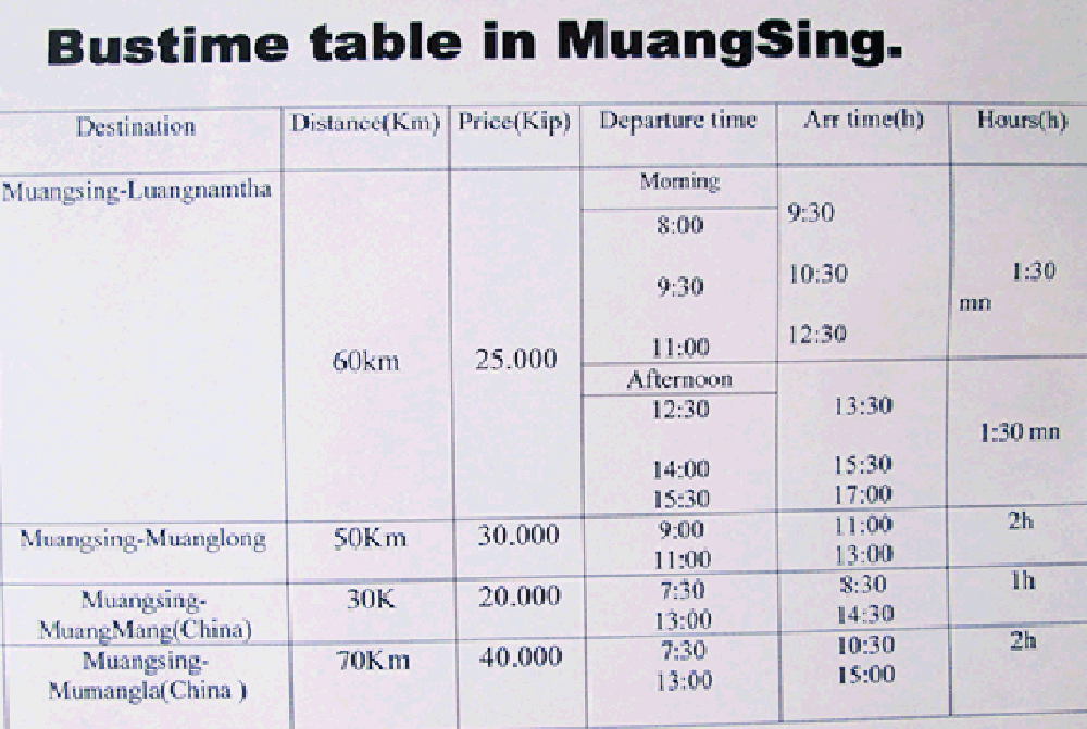
The bus schedule for Muang Long below was posted at the Luang Namhta Tourism Office June 2015. We include it here since we don't have a Muang Long web page and Muang Sing is the closest connection.
Cycling Around Muang Sing
- If you like peaceful quiet cycling on roads with little traffic then the Muang Sing area may be good for you. Some of the main roads are paved with asphalt and are in great condition but most of the more interesting roads are unsurfaced dirt roads, either dusty in the dry season or muddy in the wet season. Most roads leaving town go out thru rice fields and then into areas with rubber trees, corn or sugar cane crops. Local people are quite friendly outside of town and seem surprised to see tourists cycling in the rural areas. Unfortunately we didn't see any bicycle rental places when we last visited in April 2015.
One cycling loop we can recommend is the one going southwest out of town on the paved road towards Muang Long and Xieng Kok, then turning off onto a smaller dirt road near the Wat at Ban Khouang just before the km 6 marker and heading northeast towards an eventual junction with Hwy 17 near another Wat at Ban Nam Keo Noy around km 53.8 on the main paved road Hwy 17 going from Muang Sing to Luang Namtha. You need to make a couple turns on the small dirt roads between the main paved roads but just keep following the 3-wire electric power lines and carry a compass and a copy of this Hobo Map if possible. These dirt roads go thru Ban Hom Say (at map grid code HC155)and Ban Nam Lek (grid code HJ159).