Travel and Transport Info for Thakhek Loop, Laos by Hobo Maps - - - Home
Click to see our Thakhek Loop Map
Motorbike touring is what makes the Thakhek Loop famous. Roads around most of the Loop are wide, paved and in good condition. Much nicer than roads in Northern Laos. Independent travelers rent motorbikes in Thakhek town and spend a few days circling the 450 km Loop counter-clockwise.
Bicycle touring around the Loop is not nearly as popular. A cycler might need to peddle 600 km or more including side trips on dirt roads off the main loop roads.
Public bus transport around the Thakhek Loop is mostly by songtaew-style small buses that can carry passengers and bicycles.
The bus station schedules posted at Thakhek Bus Station are not reliable and if going to some other town along Road 13S we found it better to just go to the station and wait for buses to come and go, asking each bus crew if they have room and we usually had a short wait. We only bought a ticket after the bus arrived and had a chance to see our seats.
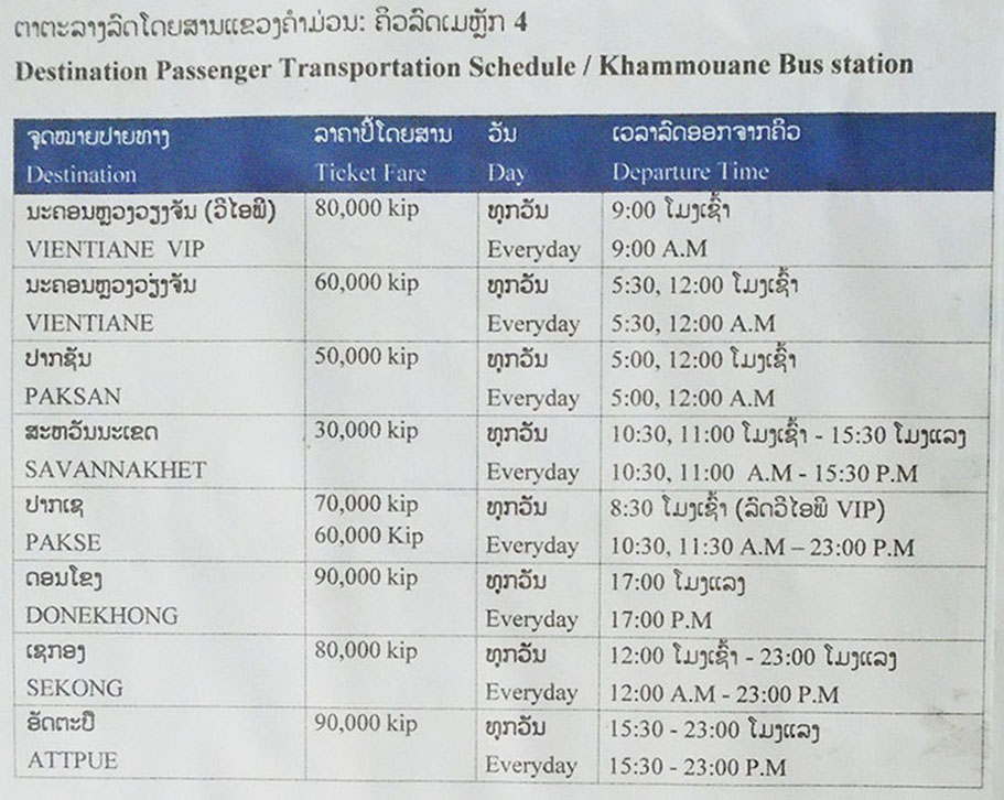
Bus schedule below at Thakhek Bus Station 4 (Khammoune Station) March 2020 - for Vientiane and Pakxan we think "9.45-24h" means many buses going between 09:45 & midnight.
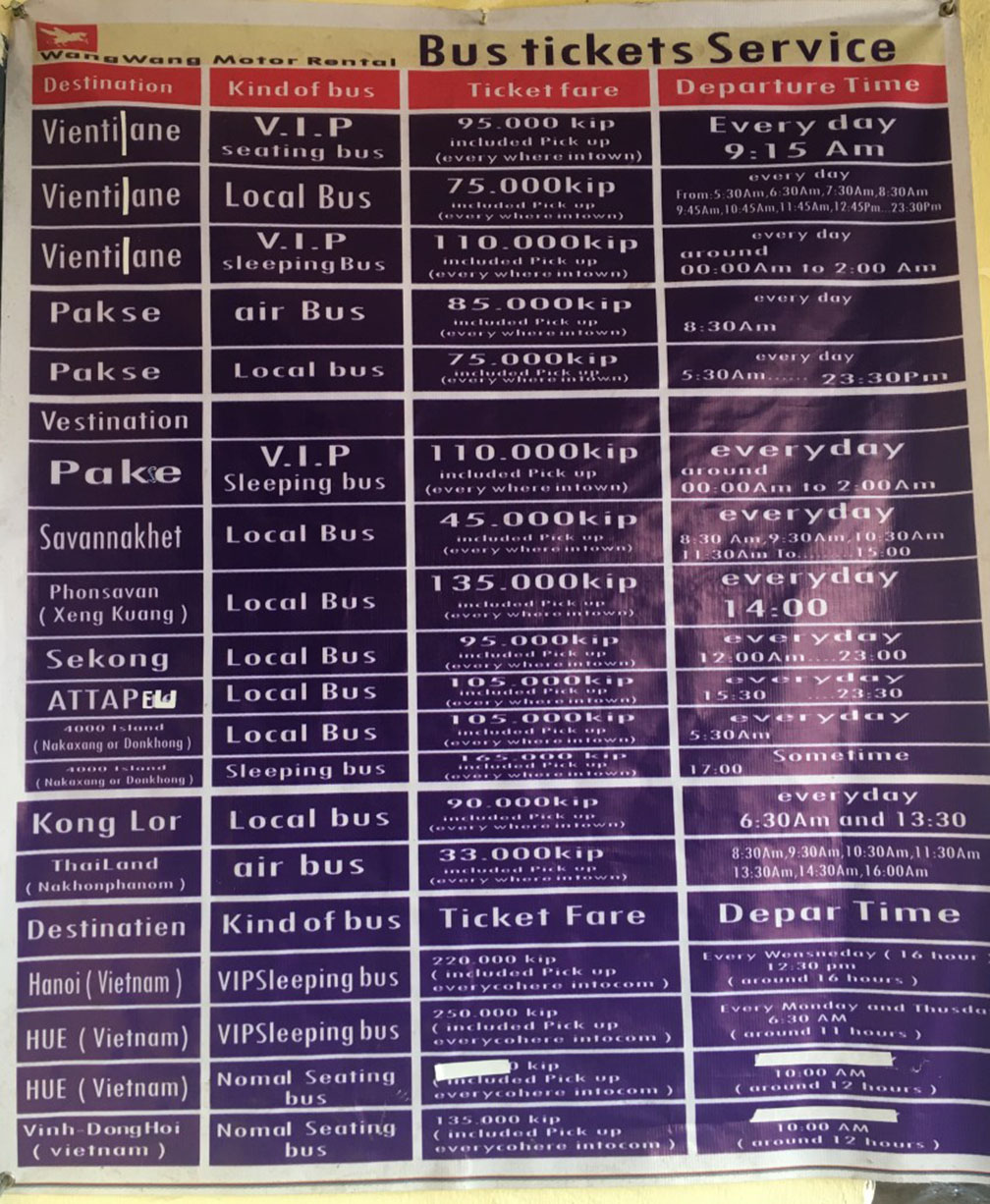
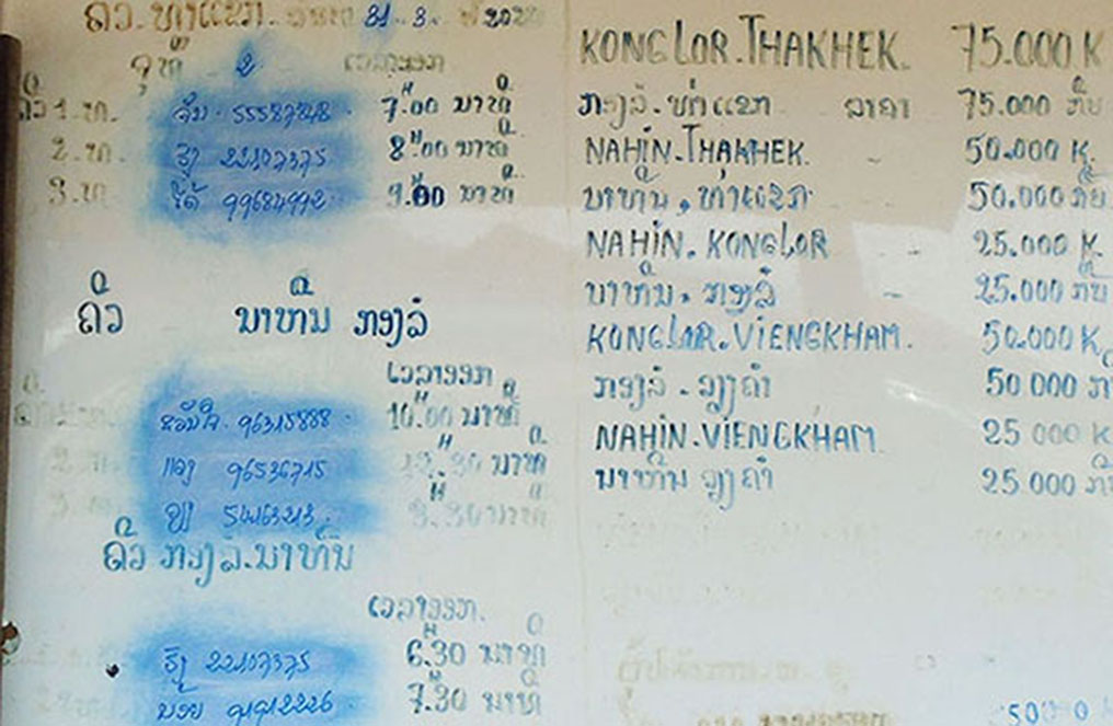
Transport schedule below from Wang Wang Motor Rental shop in Thakhek Town - unsure of date but probably 2018 or earlier. In 2023 we had a public bus departing from Thakhek at 3 PM and arrived in Konglor at 7 PM
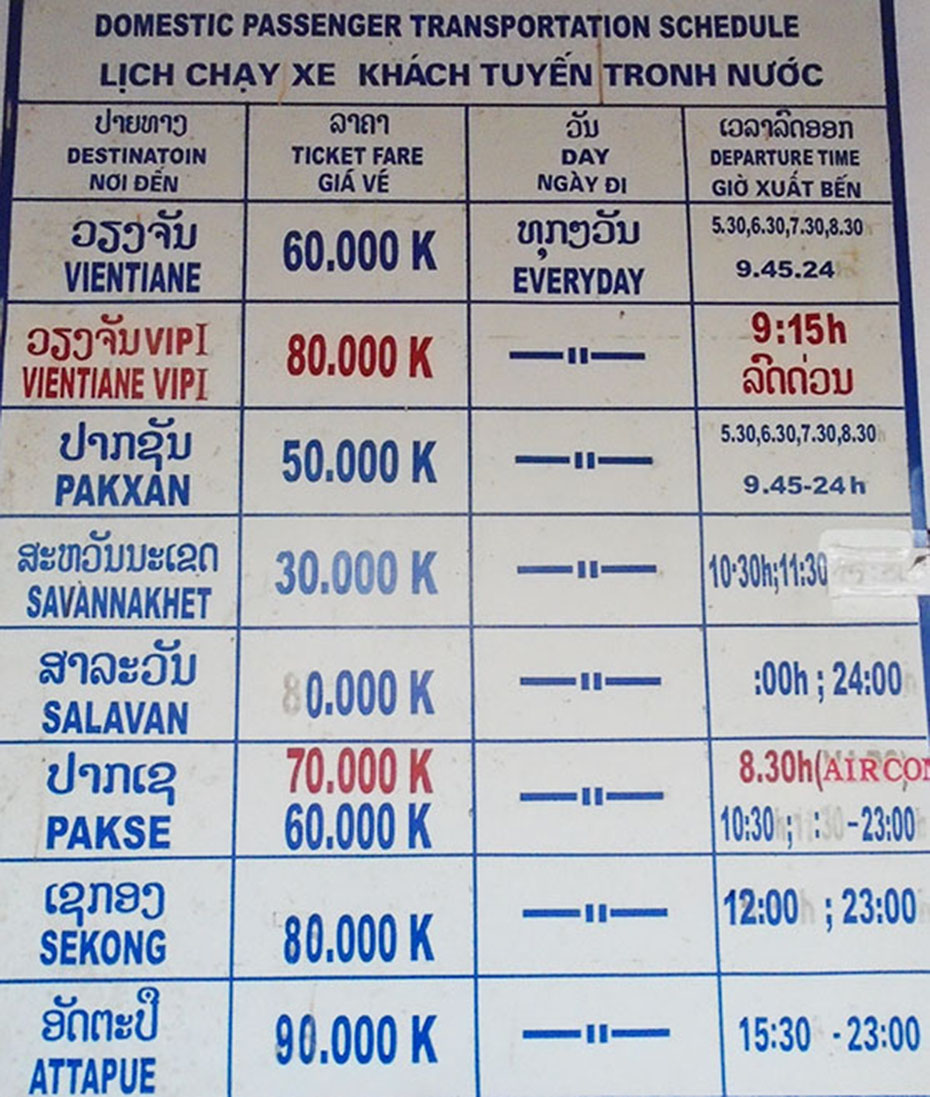
Bus schedules below from Thakhek Tourism Office March 2020 - but they look like older versions and can't be relied on
Khammouane Bus Station 4
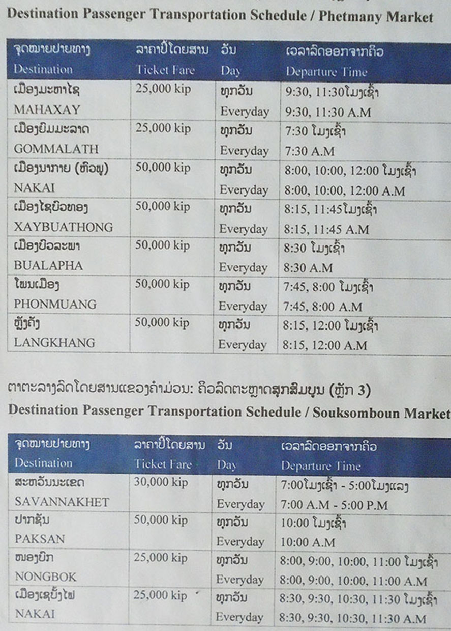
Phetmany Bus Station 2 & Soksomboun Bus Station 3 below
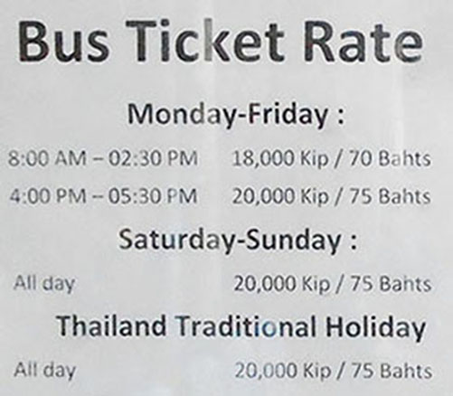
International Bus operates between Thakhek Interprovincial Bus Station (KM4 bus station) and Nakhon Phanom across the Mekong and departs every hour or so for the short trip via Friendship Bridge. The bus and cost March 2020 per below:
There are so many buses running on Highway 13S that travelers don't need to go to bus stations but can just stand beside the highway and flag down buses quite easily.
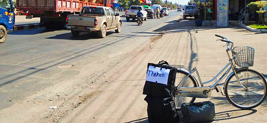
To catch buses from roadside we found it best to make a sign in English and in Lao to display beside the road since many buses don't have English signs and the crews can't read English. Just put the sign on your bags beside the road and have a seat but be ready to board the bus quickly. At first we tried asking questions before boarding but sometimes they left us standing and sped off not understanding English and not willng to waste time. You can download and print signs in English and Lao HERE for destinations around the Loop.
NAKAI
Nakai Bus Station info below:
no English signs at Bus Station and no persons in charge
- if someone is selling drinks and snacks at the station they have a key to the toilet for 2,000 kip
- someone selling in March 2020 gave me the bus schedule below:
- North to Lak Sao - one songtaew style bus per day comes thru to Lak Sao at 11:00 (starts in Thakhek). Another bus might come thru around 14:00 maybe. Takes about 2.5 hours to Lak Sao with a stop at Thalang Bridge near Phosy GH & Sabaidee GH. 50,000 kip for me & bike.
- South to Thakhek - songtaew style buses that start in Nakai depart for Thakhek at
08:00,
09:30,
10:30,
12:00,
13:30,
14:30,
15:00
and the trip takes about 2.5 hours - 50,000 kip for me and my bicycle
------------------
LAK SAO
Lak Sao is quite a decent town with a new bus station and fresh market along with nice mountain views and fresh air. Half way point on the Thakhek Loop. Border crossing traffic gives it a commercial feel. In 2020 we found several nice-looking guest houses and decent rooms go for 60,000 kip and up. Things are a bit more costly here than in other parts of Laos due to the remote location. We didn't see any public transport, tuk tuks or songtaew buses. But it's not a large town and can be walked.
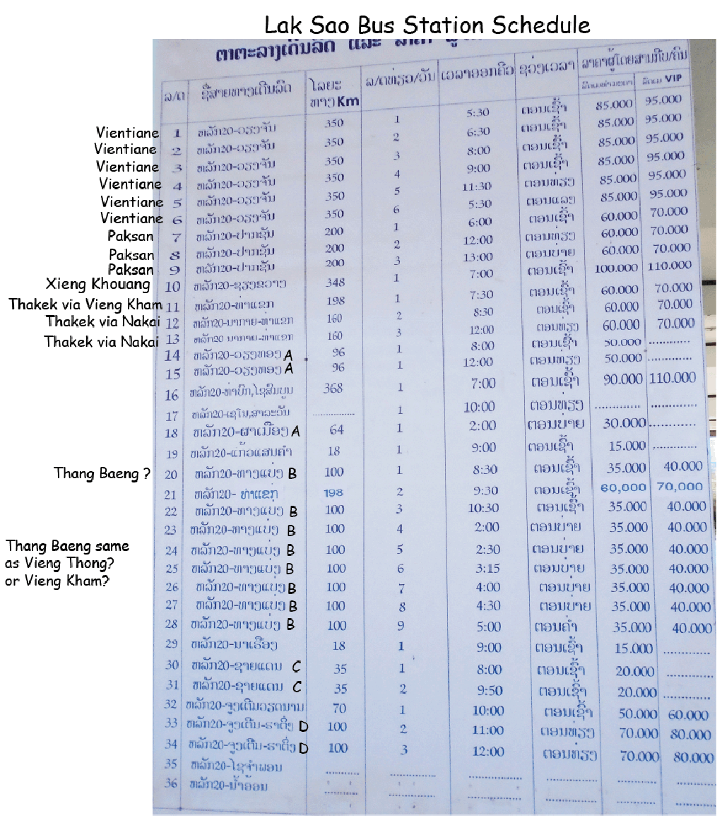
Lak Sao Bus Station schedule below is from March 2020 at the new bus station:
-----------------------------
NA HIN
The Na Hin bus station is about 3 km south of the main area for guest houses. But many buses go thru the main guest house area and will pick up passengers there by the old fresh market. The sign below was at the bus station in March 2020.
Buses Between Na Hin and Kong Lor Cave Area
A songtaew bus is scheduled to depart every morning at 07:00 from Kong Lor Cave area for Na Hin and junction with Road 8. It can be a quick trip over the 40 km distance. In March 2020 we took this bus and arrived at Na Hin around 08:40.
We think there is a daily 12:30 bus scheduled to depart from Na Hin Bus Station for Kong Lor village. Drivers seem willing to drop off local passengers and cargo at their homes and the bus may go in and out of villages as it slowly crawls along.
There are other departures on these routes but we aren't sure.
-----------------------------
Vieng Kham
There is a new bus station in Vieng Kham on Road 13S about 300 meters north of the junction with Road 8. In March 2020 there were no English signs at the station. Many locals wait for songtaew buses going east on Road 8 at the junction across from Phetsamone Hotel where there are restaurants and seats. Our songatew bus to Lak Sao left at 14:30 from the waiting area and went to the bus station before departing for Lak Sao. Only took 2.5 hours for the trip.
To take a bus north or south on Road 13S we prefer to not use the bus station but just wait at the junction of Roads 8 & 13S for buses to stop beside the road briefly. Be ready to jump on and ask questions later.
-----------------------------
Tham Heup Cave - at Northwest Area of Thakhek Loop as shown on our Loop Map HERE
Tham Heup is a cave with a river running through a mountain about 1 km in length. It can be walked with a guide and no need for a boat but the feet do get wet. Water-walking footgear is suggested. A trip to the cave begins by turning off Road 13S at Ban Samban near the km 252 marker and going 14 km on a dirt road to the Hinboun River at Ban Nakhok which can be crossed with local guides. On the other side a 1.5 km walk on a path brings visitors to the cave. It costs 50,000 kip to take a boat across the river and for a guide to take you through the whole cave. A torch is needed and the walk through the cave takes about 30 minutes. Very quiet, serene and scenic. As an option a 30 minute walk on the other side of the cave brings you to an ancient temple and another 30 minutes to the village Ban Nam Heup. A nice temple cave can be visited at Wat Pha Souk Samlan near Ban Thong Long on the way for free.
--------------------
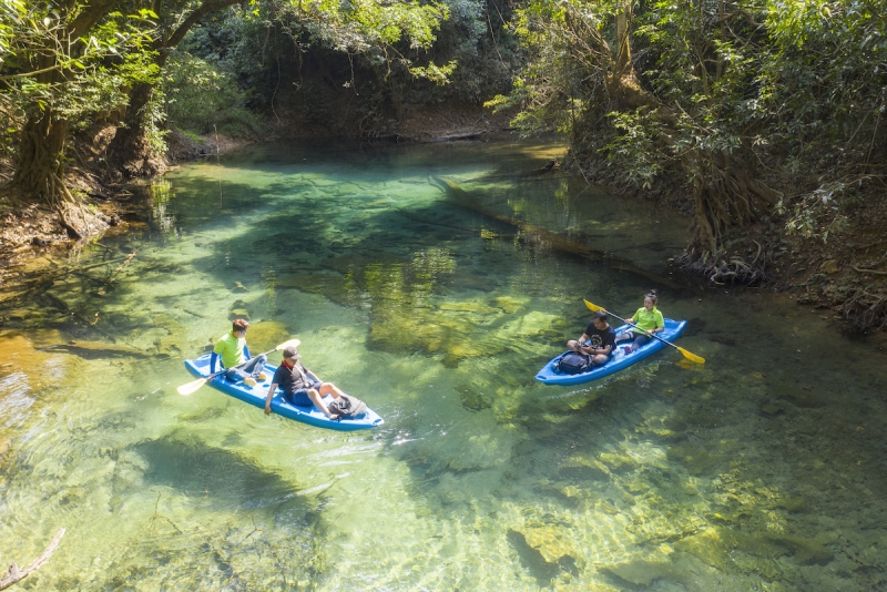
Kayak Nam Hinboun River

Kayaks are available for rent at Spring River Resort near Kong Lor Cave to go on 4 different trips:
1. From Spring River Resort kayak about 7 km upstream to Kong Lor Cave and transfer to a powered boat back and forth thru Kong Lor Cave, then kayak back to Spring River Resort
2. Can start at Kong Lor Cave and kayak one-way to Spring River Resort
3. From Spring River Resort kayak about 14 km downstream one-way to Sala Hinboun Guest House where a transport vehicle will bring you back to Spring River Resort
4. From Spring River Resort kayak self-guided about 1 km on a serene spring-fed stream with crystal-clear pools
Natane Valley is the remote place on the back side of Kong Lor Cave
Natane Valley has been mostly inaccessible for visitors to pass thru but a new road has been opened. The gravel dirt road starts at Road 1E near Ban Nakai Tai and goes north west to the eastern side of Kong Lor Cave. Not sure of the road condition in the wet season. The map sign we saw in March 2020 is below:
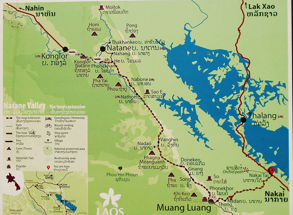
There are ongoing efforts to draw more tourists in to visit the Natane Valley. Although bicycle rentals are shown on the map we advise to bring your own bike. Some home stays in villages along the new road were also available in 2019 as shown by the bed symbols on the map.
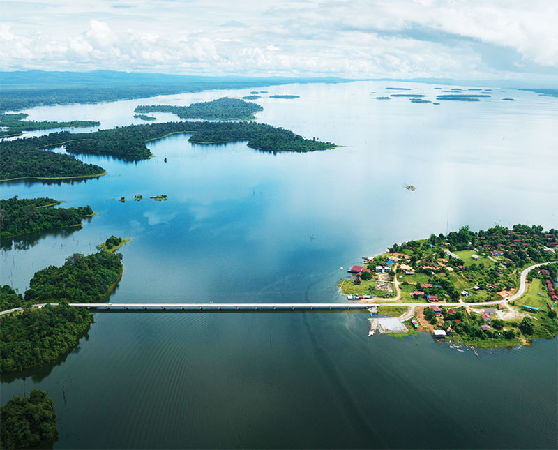
Oct. 2023 Nam Theun 2 Reservoir bridge at Thalang images below with very high reservoir water level near end of great wet season.
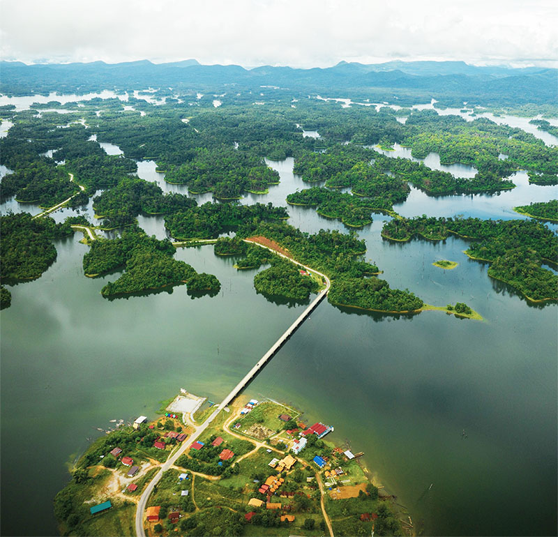
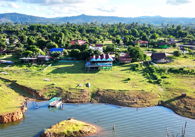
Thalang below when reservoir water levels lower:
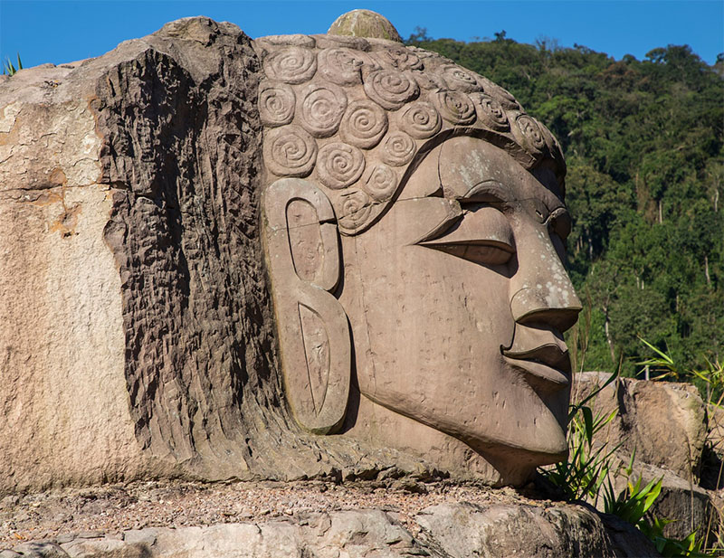
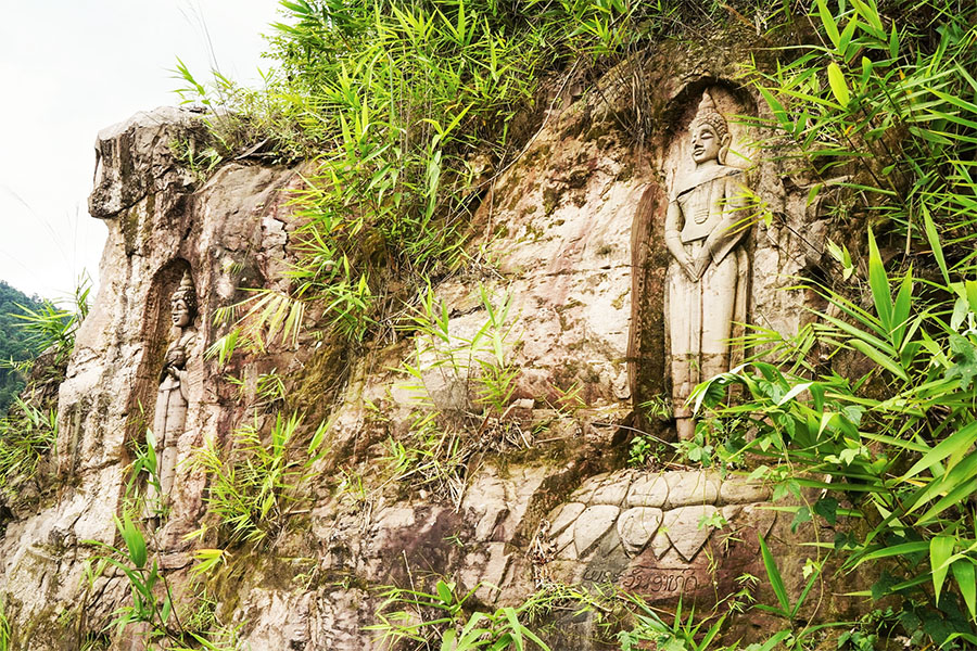
Nakai to Lak Sao be sure to stop and see Buddha relief images carved into boulders beside Road 1E at km30 marker - images below:
------------------------
See our Thakhek Loop Map HERE
See our Thakhek Loop Terrain Map HERE that shows terrain detail from satellite imagery
See our Thakhek Loop Geographic Map HERE that shows the higher Nakai Plateau and other geographic features.
See our Hydropower web page about the dams located near the Thakhek Loop HERE