
Mekong Mainstream Dams Info by Hobo Maps - Go to Hydropower Projects Page - - - Home
Satellite image map of Mekong Lower Basin below:
Summary of Mekong Mainstream Hydropower Projects - as of March 2023
The latest development plan for the Mekong mainstream in Laos consists of 9 dams - from upstream to downstream - Pak Beng, Luang Prabang, Sayaburi, Pak Lay, Sanakham, Pak Chom, Ban Koum, Phou Ngoy & Don Sahong.
They are developed by different developers as IPP (Independent Power Producer) and BOT (Build Operate Transfer).
The Xayaburi and Don Sahong projects were completed and put into operation in 2019.
The Pak Beng, Pak Lay, and Luang Prabang projects have completed the six-month consultation mechanism with Mekong River Commission while Sanakham and Phou Ngoy are preparing for submission for consultation.
1. Sayaboury (Xayaburi) Dam HPP
- located in Sayaboury Province 30 km east of Sayaboury town
- dam site at coordinates 19°14'37.0"N 101°49'10.0"E (19.243611, 101.819444)
- owned and developed by Xayabouri Power Co. Ltd.
- the project is finished and started commercial operation in October 2019
- as first Mekong mainstream dam in Laos it was subject to rigorous review and redesign, now serving as model for other Mekong projects
- offtake is exported to Electricity Generating Authority of Thailand (EGAT)
- 1,285 MW with average annual 7,370 GWh
- located in Siphandone (4000 Islands) area of Champasak Province, two kilometers from the Cambodia border
- dam location at coordinates - 13°56'38.4"N 105°57'21.6"E (13.944, 105.956)
- owned by Don Sahong Power Company with shareholders Mega First Corporation Berhad 80% & Electricite du Laos 20%
- the project is finished and began commercial operation in January 2020
- unique dam structure only blocks one channel of Mekong and leaves most of Mekong unblocked and free-flowing
- offtake is for EDL and domestic consumption with plans for most to be exported to Cambodia since a connecting transmission line has been constructed.
- 260 MW with 2,000 GWh per year
- located 25 km upstream from Luang Prabang town near Pak Ou
- site coordinates are 20°04'24.7"N 102°11'15.0"E (20.073528, 102.187500)
- site construction is underway in 2023 and major facility construction looks to continue
- owner is Luang Prabang Power Company Limited
- shareholders are PT Sole Co., Ltd. 38%, Petro Vietnam Power Corporation 10%, CK Power Public Company 42%, CH. Karnchang Public Company Limited 10%
- offtake will go to Electricity Generating Authority of Thailand (EGAT).
- 1,460 MW with yearly average capacity of 6,854 GWh
- the project has finished the Notification, Prior Consultation and Agreement (PNPCA) process with the Mekong River Commission
- located a few km north of Pak Lay town in Sayaboury Province
- located near coordinates - 18°24'05.0"N 101°35'01.0"E (18.401389, 101.583611)
- construction has started
- developed by Gulf Energy Development Plc and Sinohydro (Hong Kong) Holding Co (SHK) (60%) as a joint venture with Gulf Energy PCL having 40% ownership interest.
- China’s Sinohydro Corp. will be managing construction
- offtake will go to Electricity Generating Authority of Thailand (EGAT).
- 770 MW with average annual output capacity of 4,124 GWh
- the project has finished the Notification, Prior Consultation and Agreement (PNPCA) process with the Mekong River Commission in April 2019
- located 35 km upriver from the town of Pak Beng
- site coordinates - 19°53'45.6"N 100°49'37.2"E (19.896 100.827)
- construction has started
- developed and owned by Datang (Lao) Pak Beng Hydropower Co. and Gulf Energy Development Public Company Limited as Co-Sponsors
- offtake will go to Electricity Generating Authority of Thailand (EGAT).
- 912 MW with annual average energy production capacity of 4,765 GWh
- the project has finished the Notification, Prior Consultation and Agreement (PNPCA) process with the Mekong River Commission
- located about 1 to 2 km north of where the Thai border at Loei Province meets the Lao border on the Mekong
- dam site at coordinates - 17°49'58.8"N 101°33'00.0"E (17.833, 101.550)
- Datang (Lao) Sanakham Hydropower Co. Ltd (Chinese) is the project developer
- Thai energy company Gulf Energy PCL plans to purchase a 30% to 35% ownership interest
- offtake hoped to be exported to Electricity Generating Authority of Thailand (EGAT)
- 684 MW with average annual energy output of 3,803 GWh
- the project has finished the Notification, Prior Consultation and Agreement (PNPCA) process with the Mekong River Commission
7. Ban Koum HPP
- located a few kilometers north and upriver from Pakse in southern Laos
- dam site coordinates - 15°25'06.0"N 105°35'12.0"E (15.418333, 105.586667)
- project is still in planning stage and construction has not started
- Project sponsors: Italian-Thai Development Co., Ltd and Asia Corp Holdings Ltd. and Lao government
- Ban Koum has not yet started the Notification, Prior Consultation and Agreement (PNPCA) process with the Mekong River Commission
- installed capacity of 1,872 MW from 26 bulb turbines at 72 MW each. Estimated annual output may come to 8,012 GWh
- offtake uncertain but probably will be exported to Thailand - no power purchase agreement has yet been agreed to
- both Pak Chom and Ban Koum trans-border hydropower projects face challenges due to cross-border impacts
8. Pak Chom
- located on the Mekong about 20 km north of Pak Chom, Thailand
- located at coordinates - 18°12'12.00"N 102° 3'0.00"E (18.203333, 102.050000)
- Ministry of Energy Thailand and Ministry of Mines and Energy Lao PDR would jointly undertake the Pak Chom project initially
- installed capacity is 1,079 MW. Potential annual energy generated is estimated at 5,318 GWh
- Pak Chom is in the planning stage and has not yet started construction or the Notification, Prior Consultation and Agreement (PNPCA) process with the Mekong River Commission
- 90% of offtake planned to be exported to Thailand - power purchase agreement has not yet been agreed to
- both Pak Chom and Ban Koum trans-border hydropower projects face challenges due to cross-border impacts
- located on the Mekong River in Champasak Province about 18 km downstream and south of Pakse
- located at coordinates - 14°59'40"N 105°52'54"E (14.994444, 105.881667)
- developed by Charoen Energy and Water Asia Corporation of Thailand
- installed capacity of 728 MW with 2,800 GWh estimated annual output
- Lat Soua / Phou Ngoy is in the planning stage and has not yet started construction or the Notification, Prior Consultation and Agreement (PNPCA) process with the Mekong River Commission
- The developers hope to sell the bulk of the power generated to Thailand. As of November 2023 a power purchase agreement has not yet been agreed to

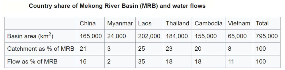
The Mekong River is about 4,900 km long and drains an area of 795,000 square kilometers. From the Tibetan Plateau the river runs through China, Myanmar, Laos, Thailand, Cambodia, and Vietnam. From its source to the border with Laos the river drops 4,400 meters rushing down narrow gorges. At the Lao border the elevation is about 500 meters above sea level and from there the Mekong flows slowly to the sea.
The Thai and the Lao refer to it as Mae Kong or Mae Nam Kong meaning ‘mother water’. In the delta, where the river splits into multiple branches, the Vietnamese refer to it as Cuu Long meaning ‘nine dragons’. In China the river is known as the Lancang Jiang, meaning ‘turbulent river’.
Image below of the Jinghong Dam on the Lancang Jiang in Yunnan China at Sipsongpanna (Jinghong).

The Mekong Basin can be divided into two parts: the "upper Mekong basin" in Tibet and China and the "lower Mekong basin" from the northern Lao border downstream to the South China Sea. The upper basin makes up 24% of the total area and contributes 15–20% of the water that flows into the Mekong River. As the Mekong enters Cambodia, over 95% of its flows have already joined the river.
75% of the Mekong’s annual flow comes with the monsoon between July and October This surge of water historically has caused extensive flooding throughout the system. As the high water flows down through the system it eventually gets to the Mekong Delta where it spreads out and begins to slow down. This causes the river level to rise and reverse its flow northwards up the Tonle River and into the Tonle Sap Lake. When the monsoon ends and the Mekong River level drops, once more the Tonle River reverses its flow and begins to flow southwards towards the delta draining the Tonle Sap Lake. The Tonle Sap’s area can grow tenfold from 2,500 square kilometers before the rains to 25,000 square kilometers at the end of the rains.

Mekong Style
Mainstream Mekong dams typically have the powerhouse and turbines placed in the barrage dam structure. They create artificial head (elevation drop) by raising the Mekong water level behind the dam. These dams usually generate electricity continuously and not in a peaking "on demand" manner. The dams and reservoirs can be developed in a cascade manner with the same water turning turbines several times as it flows down. Some tributary rivers such as the Nam Ou, Nam Kong, Nam Yeuang, Nam Ngum, etc. are also suitable for development as cascades.
The Mekong dams in the Lao cascade are all run-of-the-river (small storage), they will have negligible influence on the overall annual flow regime, particularly if compared to the effects of the Chinese dams and tributary dams.
Impoundments on the mainstream schemes as currently envisaged are to create head and not storage. The creation of these impoundments obstructs fish migration, traps sediment, reduces water quality and increases aquatic footprint.


Chart below shows Mekong tributaries percentage of contribution to the river's flow. Left bank is on the left side looking downriver and has the biggest contribution.

Diplomatic History
In 1995, the governments of Cambodia, Laos, Vietnam and Thailand jointly established the Mekong River Commission (MRC) in order to strengthen transboundary water governance. Their goal is to promote and coordinate sustainable development and management of water within the Lower Basin countries. China declined to join as a full member; along with Myanmar, which has observer status, saying they prefer to negotiate any issues with the Mekong or water development on a bilateral basis.
In 2015, China launched the Lancang-Mekong Cooperation (China uses the term Lancang to refer to the section of the Mekong within China). The goals of the LMC are similar to the MRC but the LMC is a bilateral organization, headquartered in Beijing and primarily funded by China. The structure of the LMC is to promote interaction among high-level officials in order to boost trade deals between China, Myanmar, Laos, Thailand, Laos, and Vietnam. The endorsement and participation from all six Mekong countries is significant because it allows China to possess a stronger degree of control over the Mekong River and have greater control over future dam buildings.
Mekong River Commission
The Mekong River Commission is an intergovernmental organization for regional dialogue and cooperation in the lower Mekong river basin that was established in 1995 based on the Mekong Agreement between Cambodia, Lao PDR, Thailand, and Viet Nam. The organization serves as a regional platform for water diplomacy as well as a knowledge center for water resources management and sustainable development of the region. The Commission operates from its headquarters in Vientiane and has a website page and a Facebook page.
The MRC is an entirely advisory body that provides research, surveys and coordination of water-related resources development in the Lower Mekong Basin. China has been added as a Dialogue Partner but is not a member of the body.
Funded by the four member countries and donors, the MRC has no authority to stop a dam from being built on the mainstream of the Mekong. But the MRC can play an important advisory role through a process called Procedures for Notification, Prior Consultation and Agreement (PNPCA). This process involves MRC members reviewing the benefits and risks of mainstream Mekong projects against environmental, safety, development and other related concerns prior to the beginning of construction.
The Xayaburi and Don Sahong projects have completed the PNPCA process and are operational. Pak Beng, Pak Lay, Luang Prabang and Sanakham have undergone the PNPCA process and are set to begin construction.
The MRC has released a Basin Development Plan 2021-2030 and a Five-Year Strategic Plan to better understand the development and climate change challenges facing the Mekong river.

Mekong monitoring stations map below.

Changing style and color of the Mekong
If all of the proposed Mekong mainstream dams in Laos are in operation, the Mekong will have a series of reservoirs that nearly reach back to the next upriver dam creating a stepped reservoir system. The Mekong will seem more like a series of lakes than a river due to these backwater effects. Rapids and whirlpools will be a thing of the past. It seems that all these dams will have navigation locks that allow transit of boats up to 500 tons through the dam structure so boat traffic will still be viable but slow. On the plus side boat travel should be safer with deeper and more consistent water depth.
In March 2020 around Savannakhet we saw the Mekong having a clear and blueish color which was quite a shock. It seems the water released from the upriver Sayaboury dam was the cause.
Mekong historic and traditional color below - reddish muddy brown:

Mekong clear blue at Savannakhet bridge in March 2020 downriver from Sayaboury Dam discharge.

Terrain map below shows Mekong catchment basin as tan-colored area.

Mekong River water level chart below for Luang Prabang below from Mekong River Commission website page. Current water level at 276 masl matches the backwater full supply level of 275 masl for Sayaboury Dam HPP and shows that the backwater pond does reach all the way to L. Prabang.

Mekong mainstream dam reservoirs in Laos chart below - some old data below that has been revised so not reliable data.

Transmission line chart below shows routes for power export to Thailand for some of the mainstream Mekong dams.
